
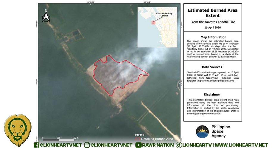

This image shows the estimated burned area affected in the Navotaslandfill fire, which reportedly broke out on 10 April 2026. As of Thursday (16 April, 10:33AM), sixdays after the fire reportedly broke out, there was an estimated 28.58 hectares (~285,800 sqm)of burned area (delineated in red). For comparison, this area is slightly larger than the QuezonMemorial Circle.The Philippine Space Agency (PhilSA) produced this map and provided it to the NDRRMC.
PhilSA’s support through images and maps provides wide-area coverage that guides NDRRMC in monitoring the situation and prioritizing areas for response. By making space data accessibleto stakeholders, PhilSA enables informed decision-making and strengthens disaster response.PhilSA analyzed the near infrared band of a Sentinel-2C satellite image captured on 16 April 2026at 10:33 AM PhST. Please be advised that the maps provided by PhilSA are subject to fieldvalidation.
Access the high-resolution map and shapefile here: https://bit.ly/NavotasLandfillFire
Republic of the Philippines Office of the PresidentPhilippine Space Agency Read this on our website:
https://philsa.gov.ph/news/satellite-image-on-thursday-16-april-shows-28-6-hectares-burned-in-navotas-landfill-fire/Follow us on social media for the latest updates: https://linktr.ee/philspaceagencyPrevious releases on the Navotas landfill fire can be found below:•
(Released 17 April 2026, access here.) Satellite data show smoke from Navotas firereached as far as Bataan
